Trekking Grade
Trekking Category
Lower Dolpo is one of the most remote and naturally rewarded areas, lies in the western part of Nepal. Here we can discover gray hills and dry alpine grazing deserts. Greenery is seen less. In the daytime, strong winds carry a lot of dust. The beautiful landscapes and serenity remind us we are in Tibet.
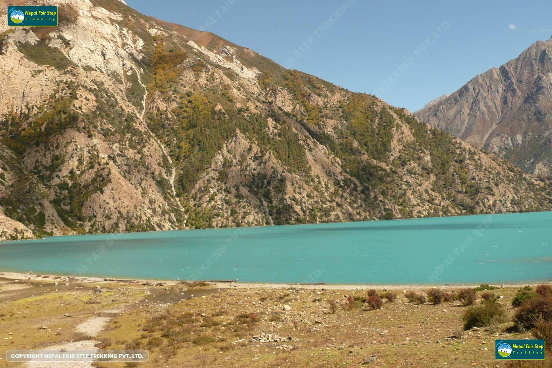
The journey begins with a short scenic flight from Kathmandu to Nepalgunj, followed by another 30-minute flight to Juphal, the start point of the trek. We walk through several beautiful villages and places until we reach the dense forests of Shey Phoksundo national park, where you can see the different species of flora and fauna. Another highlight of the trek is Phoksundo Lake, a serene freshwater surrounded by soaring cliffs that reminds us of a dreamy image from a fictional novel. Excursions to the ancient monasteries (gompas) and Bonpo shrines surrounding the lake make your trekking trip a lifetime memory. Next to Phoksundo Lake, you can visit Ringmo village, well-known for its Buddhist and Bon Po cultures.
Lower Dolpo region is permanently inhabited by different ethnic groups of Nepal such as Bohora, Thakali, Magar, Tibetan, and Bhote. They have their typical Buddhist and Tibetan culture and well-preserved Bon po religion. Guru Rinpoche is said to have blessed the entire region in the 8th century, and it has long been a refuge for devout Buddhists in difficult times.
As Lower Dolpo is one of the most remote areas in Nepal, so every trekker should have the guts to endure lots of difficulties during the trek. Trekkers should have sound health and good trekking experience to accomplish this trek. A special trekking permit should be required before trekking to the Dolpo region. As Nepal Fair Trekking is a government-registered trekking agency, we will manage to obtain special trekking permits for the lower Dolpo trek. From Phoksundo Lake, we return to Juphal via. Chepka and Dunai villages. The next day we fly back to Kathmandu via. Nepalgunj.
Lower Dolpo trekking can be done from mid-March to November. For Lower Dolpo trekking it would be better to have flexible timing as there could be a high chance of flight cancellation due to the bad weather in Juphal.
a representative from Nepal Fair Step Trekking will be waiting for you at Tribhuwan international airport with a board displaying your name. She/he will welcome you with a Khata – a traditional scarf – and take you to your hotel. You will be informed about the program and schedule of the next days. In the evening, someone from Fair Step Trekking will take you out for dinner. Overnight in Hotel. (D)
our city guide will take you around the city and shows you the most historical and spiritual sites in Kathmandu: Durbar square, the living goddess Kumari, Pashupatinath Temple, and Boudhanath stupa. You will learn about our history, culture, religion, and the daily life in Kathmandu. (B)
The flight from Kathmandu to Nepalgunj takes about 50 minutes. Nepalgunj is the largest town in Western Nepal. Nepalgunj is about 6 kilometres away from the Nepal-India border. You can experience both the Hindu and the Muslim culture. Overnight in hotel. (B, L D) )
Jhuphal is beautifully located in the Himalayan foothills. During our 40-minute flight to Juphal, you can admire much more snow-capped mountains. You will meet your trekking crew in Jhuphal village, before heading to Dunai (2150m). The distance from Jhuphal to Dunai will be about 12 km. We will first descend 400m down to the Thulo Bheri River before we continue walking on a mostly flat track, only ascending about 100m. Estimated walking time is 4 hours. Overnight in camp. (B, L D) (12km: 4h, ↑100m, ↓400m, )
Today we trek from Dunai (headquarter of the Dolpo region) to Tarakot. Estimated walking time is 5-6 hours (approx. 15km, ascending about 400m). We follow the southern bank of the TholuBheriRiver (Barbung Chu), crossing suspension bridges, passing beautiful villages and several deep gorges, before reaching the historical village of Tarakot. Overnight in camp. (B, L D)
The distance today will be about 19 km(approx. 300 m downhill and 800 m uphill), taking us 6 -7 hours. We follow the valley of the Barbung Chu till Khanigoun, and then follow the Tarap Chu River to the left. Different vegetation, the sound of many birds, the view of Putha Himal and Chorten and two Bunpo monasteries are the highlights of the day. Overnight in camp. (B, L D) (Walking Time: 6 h. ↑800m, ↓300m,18 km)
The hike today is quite exciting as the valley becomes a narrow gorge; we follow a simple trail to Naworpani. Walking time today is about 5 hours. Overnight in camp. (B, L D)
Our trail follows the Tarap Chu, alternating between the two sides of the river. We will pass rural villages, barren cliffs, a ridge with mani walls and a chorten. Today we’ll cover approx. 18 km, ascending 700 m and descending 150 m to reach the fascinating Buddhist village of Do Tarap. Overnight in camp. (B, L D)
The day off will help our body to get used to the altitude. We’ll go for short walks around the village, we’ll visit nearby monasteries (Ribo Gumpa, KakarLabrag ,Dakmar Dewa) and get acquainted with the local culture, history and tradition while visiting a locals house. Overnight in camp. (B, L D)
We continue our trek towards the upper Tarap valley. We follow theTarap Chu, observing a changing landscape. TheCrystal mountain school, traditional houses, wooden bridges and a statue of the MaitreyaBuddha will be our highlights of the day. Walking time will be approx. 4 hours .Overnight in camp. (B, L D)
Toda your journey starts early in the morning.We begin crossing the Numa La pass (5190 m) on a steep trail all the way to the top ridge of the pass. From the pass, you will get incredible views of Dhaulagiri (8167m), Kanjirowa (6139) and other snow-capped mountains. Afterwards, we will descend to Peluntang. hours .Overnight in camp. (B, L D)
After breakfast, we begin our steep climb up to the top of Baga La pass. We reach the top of BagaLa in about 3 hrs and then enjoy fantastic views of the dry landscape and the distant snow-capped mountains including Kanjirowa Himal. We then descend to Da jo Tang for our overnight stay. Overnight in camp (B, L D)
It’s a short hike today, only about 3 hours. We start our trip through beautiful pine forests and then through alpine vegetation. After trekking for a short while on an easy trail with only gradual highs and lows, we reach Ringmo Village. Overnight in camp. (B, L D)
This is a pleasant day off, without the hassle of packing and unpacking. You have the chance to visit the nearby Tibetan Buddhist monastery or spend some time in the village of Ringmo. You can also enjoy a relaxing walk on the lake’s shores. This is a great day exploring the Phoksundo Lake and camp at its shores. Overnight in camp. (B, L D)
Today we first follow a level path, before climbing a steep trail. After an hour-long uphill climb, we arrive atop a hill from where the river we followed earlier begins to diminish in size. One more time we take a look at beautiful Phoksundo Lake before descending to Chunuwar. Beyond Chunuwar, the trail descends gently along lush forests of pines and birches all the way to Rechi. We follow the river on an easy trail with only gradual highs and lows and finally reach Chepka. This part of the trek is about three hours long. Before reaching Chepka, we begin to see the first signs of tropical forest, such as bamboo forest and walnut trees.Overnight in a camp in Chepka. Overnight in camp. (B, L D)
we are following Suli River through beautiful villages, giant cliff and hilly fields. To reach our destination today may take approximately 5 hours. You will walk about 13 km as well as 375m ascending and 975m descending. Overnight in camp.(B, L,D)
Today is our last day of uphill and downhill (Trekking) with our trekking crew. We walk about 14 km, descending 875m and ascending 750m to reach Juhphal. We celebrate last evening dinner with our all trekking crew. Overnight in camp. (B, L D)
Overnight in hotel. (B, L, D)
Overnight at the hotel. (B, L, D)


